map of the lands of the jewish captivities - babylon map stock illustrationsMap of the lands of the Jewish CaptivitiesMap, Ancient History, Ancient Babylon
map of eden and mount ararat, copperplate engraving, published 1774 - babylon map stock illustrationsMap of Eden and Mount Ararat, copperplate engraving, published 1774Map, Ancient Babylon, River Tigris
Clay tablet Babylonian map of the world. Dated 700 BCClay tablet Babylonian map of the worldHillah, Clay, Map
plan of ancient babylon, wood engraving, published in 1893 - babylon map stock illustrationsPlan of ancient Babylon, wood engraving, published in 1893Hillah, Ancient Babylon, Map
plan of the ruins of babylon according to oppert and reclus - babylon map stock illustrationsPlan of the ruins of Babylon according to Oppert and ReclusAncient Babylon, Map
Beers Map of Babylon and Huntington, Long Island, New York.1873 Beers Map of Babylon and HuntingtonBabylon - New York, Land
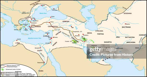
The Persian Royal Road was an ancient highway reorganized and rebuilt by the Persian king Darius the Great of the Achaemenid Empire in the 5th...Middle East: Map of the Persian Achaemenid Empire and the section of the Royal Road noted by Herodotus c. 5th century BCE, with location of Maka, now including Dubai in the United Arab Emirates. Map by Fabienkhan (CC BY-SA 3.0 License)Map, Silk Road
Sketch-map of Alexander's Chief exploratory marches from Athens to Hyderabad and Gaza. The dotted line shows the course of Nearchus' voyage down the...A sketch-map of Alexander's Chief exploratory marches from Athens to Hyderabad and Gaza.Map, Alexander the Great, Hyderabad - India
Empire of the Caliphate - map in 750. The Caliphs were the early leaders of the Muslim nation. Left hand square shows map of Spain (Andalusia,...Empire of the Caliphate, in 750 -Map, Mesopotamian, Islam
illustration showing the first cities around the world at wasserburg bachau, babylon, mohenjo-daro, shadoof irrigation, and the olmecs' la venta - babylon map stock illustrationsIllustration showing the first cities around the world at Wasserburg Bachau, Babylon, Mohenjo-daro, Shadoof irrigation, and the Olmecs' La VentaMohenjodaro, Olmec Head
Map of Asia Minor and Africa, 1595. 'Alexandri Magni Macedonis Expeditio [The Expedition of Alexander the Great of Macedon]; Iovis Ammonis Oraculum...Map Of Asia Minor And Africa
Map of Egypt and Near Eastern Kingdom in Ancient Times. . Close up map of Egypt and Palestine at time of Thutmosis III / Thutmose. Key to map: blue...Map of Egypt and Near Eastern Kingdom in Ancient TimesMap, Babylonia, Empire
The Babylonian Map of the World, c. 510-c. 500 BC. Found in the collection of British Museum. Artist : Assyrian Art.The Babylonian Map of the World, cMap, Babylonia, Clay
Map of Babylon, Assyria, Media and Susiana, countries of the Jewish Captivities. From The Holy Bible published c.1910. .Map of Babylon
Two US coalition soldiers walk in front of a map of Iraq hung on the museum wall at ancient city of Babylon south of Bagdad 13 June 2004. Iraq's US...IRAQ-US-BABYLONMap, Baghdad, Iraq
Map of the World, probably from Sippar, southern Iraq, Babylonian, c700-c500 BC. This tablet contains both a cuneiform inscription and a unique map...Map of the World, probably from Sippar, southern Iraq, Babylonian, c700-c500 BC.Babylonia, Map, Cuneiform
This 1903 illustration shows a map of the eastern world in the time of Nebuchadrezzar. Nebuchadnezzar was king of Babylon 605-562 B.C. He determined...Map of Eastern World in time of Nebuchadrezzar
Picture taken 13 June 2004 shows a painting depicting the ancient city of Babylon, 100 kms south of Baghdad. The last remains of some of mankind's...IRAQ-US-TRANSITION-CULTURE
The Persian Royal Road was an ancient highway reorganized and rebuilt by the Persian king Darius the Great of the Achaemenid Empire in the 5th...Middle East: Map of the Persian Achaemenid Empire and the section of the Royal Road noted by Herodotus, c. 5th century BCE. Map by Fabienkhan (CC BY-SA 3.0 License)Map, Middle East, Silk Road
Clay tablet depicting a Late Babylonian map of the World. Dated 700 BC.Clay tablet depicting a Babylonian map of the World.Babylonia, Map
Map of Babylonia and it's extent at different periods in history. Dated 19th CenturyMap of BabyloniaAncient
Map of Cairo, 1595. 'Cairos, quae olim Babylon; Aegypti maxima urbs'. Map of Cairo, from Vol. 2 of Mercator/Braun and Hogenburg/Blaeu Composite...Map Of CairoCairo, Map
Map of the world. This celebrated map shows the world as a disc, surrounded by a ring of bitter water.Map of the world. This celebrated map shows the world as a disc, surrounded by a ring of bitter water.
Map of the world. This celebrated map shows the world as a disc, surrounded by a ring of bitter water.Map of the world. This celebrated map shows the world as a disc, surrounded by a ring of bitter water.
Map of the world. This celebrated map shows the world as a disc, surrounded by a ring of bitter water.Map of the world. This celebrated map shows the world as a disc, surrounded by a ring of bitter water.Map, Creativity, Ancient
Map of the world. This celebrated map shows the world as a disc, surrounded by a ring of bitter water.Map of the world. This celebrated map shows the world as a disc, surrounded by a ring of bitter water.Map, Ancient, Creativity
Babil) was a significant city in ancient Mesopotamia, in the fertile plain between the Tigris and Euphrates rivers. The city was built upon the...Iraq / Mesopotamia: View of ancient Babylon, Description de L'Universe, Alain Manesson Mallet, Paris, 1683Map, Iraq
Map of Babylonia and it's extent at different periods in history. Dated 19th Century.Map of Babylonia.
illustrated map of ancient babylon - babylon map stock illustrationsIllustrated map of ancient BabylonMap
Plan of the ruins of the Nabucodonosor's palace of and the gardens of Babylon, Iraq, engraving by Lemaitre from Chaldee, Assyrie, Medie, Babylonie,...Plan of the ruins of the Nabucodonosor's palace
Touristin mit Rucksack und Stadtplan am Rosa-Luxemburg-Platz vor dem Kino Babylon in Mitte- 2000Tourismus Berlin 1990-
Map showing what ancient Babylon, one of the Seven Wonders of the World, must have looked liked is seen at the entrance of the site in southern Iraq...TO GO WITH STORY BY HASSAN JOUINI-- A ma
Clay tablet depicting a Late Babylonian map of the World. Dated 700 BC.A Babylonian map of the World.Babylonia, Clay, Map
Two US coalition soldiers walk in front of a map of Iraq hung on the museum wall at ancient city of Babylon south of Bagdad 13 June 2004. Iraq's US...Two US coalition soldiers walk in front
map and diagrams from old french atlas (1899): babylon - babylon map stock illustrationsMap and diagrams from old French Atlas (1899): Babylon
This Babylonian/Chaldaean map of the world was drawn by the French artist Henri Faucher-Gudin from a sketch by Peiser for a book on ancient Egypt by...Chaldaean Map
James Luisi, left, assists Jack Zimmermann, right, of Islip, as students read navigational charts at the Nautical School of Maritime Licensing in...Pupils reading nautical charts at Nautical School of Maritime Licensing in Lindenhurst, New York
Imagined situation of the Garden of Eden, in this case, in Mesopotamia, just east of Babylon. After a map by Jan Luyken from a work by Samuel...Imagined situation of the Garden of Eden
Karte of Assyria and Babylon, following this History, Map of the Assyrian Empire, Fig. 4, according to p. 148, Histoire universelle depuis le...Karte of Assyria and Babylon
isometric gardens of babylon - babylon map stock illustrationsIsometric Gardens of BabylonIsometric Projection, Hanging Basket, Babylonia
Statue representing a Sumerian prince is presented in the exhibition "Babylon", on March 10 at the Musee du Louvre in Paris. The exhibition, which...FRANCE-ENTERTAINMENT-ART-BABYLONE
Coalition soldier takes a photograph depicting the ancient city of Babylon, south of Baghdad 13 June 2004. Iraq's US governor and the top US military...IRAQ-US-AL HILLA-CONVOY
Die Hure Babylon, D 1997, Regie: Erwin Keusch, AXEL MILBERG, Stichwort: Stadtplan.DER MANN FÜR ALLE FÄLLE - Die Hure Babylon
This picture taken on October 29, 2021 shows a view of a map of modern Iraq displayed on the wall of the Nebuchadnezzar II Museum at the...IRAQ-CULTURE-POLITICS-ART-SOCIAL-FESTIVAL
illustration of lion in front of map highlighting territory of ancient babylon - babylon map stock illustrationsIllustration of lion in front of map highlighting territory of ancient Babylon