Poster produced for the Great Western Railway , promoting South Devon as a holiday destination, showing a pictorial map of the coastline, illustrated...Sunny South Devon, GWR poster, 1923-1947.
Engraving by royal geographer William Faden based on the Channel Chart of 1784. Eddystone Rocks, 14 miles off the coast of Plymouth in Devon, are the...�General Chart of the Seas surrounding the Eddystone Lighthouse�, 1784.English Channel, Chart
Engraving by royal geographer William Faden based upon a topographical plan of Plymouth Sound and Martyn�s large map of Cornwall. Eddystone Rocks, 14...�Map of the Coast and Country opposite the Eddystone Rocks�, 1789.
Engraving by royal geographer William Faden after an original drawing by John Smeaton. Eddystone Rocks, 14 miles off the coast of Plymouth in Devon,...�A General Plan of the Eddystone Rocks�, 1785.
This chart shows the location of the Spurn Point lighthouse, designed in 1767 by the English civil engineer John Smeaton, and built on the mouth of...�Plan of the Spurn Point� lighthouse, River Humber, 1786.
Engraving of 1784 by J Record showing a sectioned illustration of the Spurn Point lighthouse designed by English civil engineer John Smeaton in 1767....�Section of the high lighthouse upon the Spurn Point�, c 1767.
Soldier from 6 RIFLES looks at a map on the range at Okehampton Camp, Dartmoor, during the 6th Battalion, The Rifles' Annual Deployment Exercise near...HRH The Duke Of Gloucester Watches 6th Battalion Rifles On ExerciseMap
tourists study a map whilst sitting by the side of the estuary of the river dart in dartmouth. - devon map stock pictures, royalty-free photos & imagesTourists study a map whilst sitting by the side of the estuary of the River Dart in Dartmouth.
tourists study a map whilst sitting by the side of the estuary of the river dart in dartmouth. - devon map stock pictures, royalty-free photos & imagesTourists study a map whilst sitting by the side of the estuary of the River Dart in Dartmouth.
British racing driver Peter Collins planning a trip on his yacht with his father, Dartmouth, July 1956.Ckark And SonMap
Woman in a red coat reading a tourist information sign in Plymouth Devon England UK.Woman in a red coat reading a tourist information sign
school girl holding globe of the world - devon map stock pictures, royalty-free photos & imagesschool girl holding globe of the world
George Swan of Clinton Aviation and women pilots and trainees go over cross-country maps at Clinton's headquarters at Stapleton. It's part of ground...Denver Post Archives
Windsurfer Adam Cowles is offered a map by his wife, Sarah Cowles, after he accidentally surfed 40 miles to Devon from Swansea Bay across freezing...ADVENTURE Surf
Map is studied showing the area of the boar hunt near East Anstey, Wednesday January 4, 2006. Around 100 of his animals scampered to freedom in the...ANIMALS Boar
Snipers map-reading during training at the Royal Marines Commando Training Centre in Lympstone, Devon, October 2007.Map Reading
Snipers prepare to stalk a target during training at the Royal Marines Commando Training Centre in Lympstone, Devon, October 2007.Sniper
map of sedgemoor, somerset, england victorian engraving, 1840 - devon map stock illustrationsMap of Sedgemoor, Somerset, England Victorian Engraving, 1840
working arm, glass globe paperweight - devon map stock pictures, royalty-free photos & imagesWorking arm, Glass globe paperweight
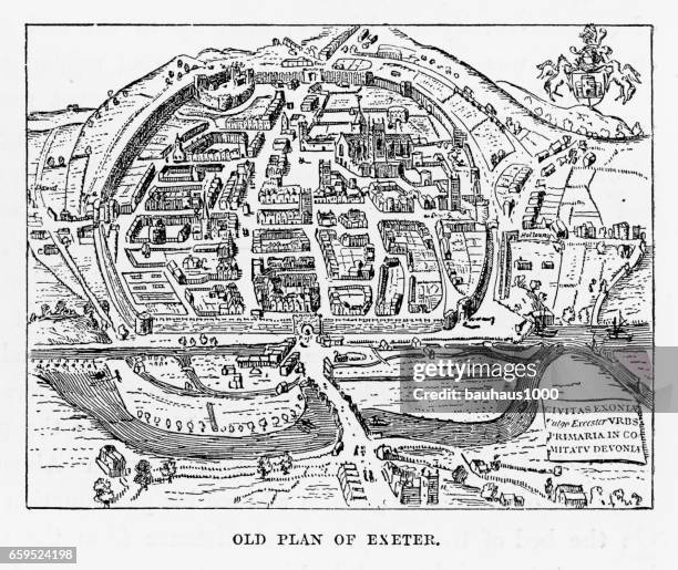
map of exeter in devon, england victorian engraving, 1840 - devon map stock illustrationsMap of Exeter in Devon, England Victorian Engraving, 1840
old plan of exeter in devon, england victorian engraving, 1840 - devon map stock illustrationsOld Plan of Exeter in Devon, England Victorian Engraving, 1840Exeter - England
Person reading information board along the Tarka Trail at Fremington Quay, Devon, UK.Person reading information board along the Tarka Trail
North America, USA, Missouri, St. Joseph, National Pony Express Museum, Interior, Wagon Trail Map.Missouri, St. Joseph, National Pony Express Museum, Interior, Wagon Trail Map
scientist checking test map of silicon wafer in laboratory, close up - devon map stock pictures, royalty-free photos & imagesScientist checking test map of silicon wafer in laboratory, close upIndustry
scientist checking test map of silicon wafer in laboratory - devon map stock pictures, royalty-free photos & imagesScientist checking test map of silicon wafer in laboratory
silicon wafer map on screen in clean room laboratory, close up - devon map stock pictures, royalty-free photos & imagesSilicon wafer map on screen in clean room laboratory, close up
Public Barometer, Information map and old drinking fountain, Noss Mayo, Devon, UK.Public Barometer, map and old drinking fountain, UK
Plymouth, 1884. From The Illustrated Naval and Military Magazine Volume I [The Illustrated London News, London, 1884] Artist: Unknown. )Plymouth, 1884.Full Frame, Map
Old Map of the Road from Dartmouth to Minhead in Somerset-ShireOld Map of the Road from Dartmouth to Minhead in Somerset-Shire
tourists and friends having a break in sultanhamet district - devon map stock pictures, royalty-free photos & imagesTourists and friends having a break in Sultanhamet district
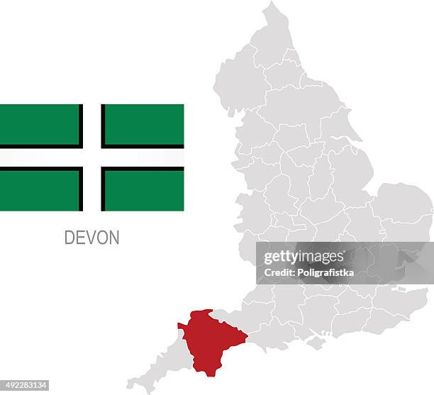
flag of devon and location on england map - devon map stock illustrationsFlag of Devon and location on England map
Walker leans on a gate to consult her map in the open countryside near Seaton in Devon.Country Walking
man holding map in car - devon map stock pictures, royalty-free photos & imagesMan Holding Map in Car
man holding map in car - devon map stock pictures, royalty-free photos & imagesMan Holding Map in Car
Geological map of Cornwall and part of Devonshire showing the principal groups of mineral lodes.British MineralsUK
logan county, nebraska map. round icon with long shadow on red or blue background - devon map stock illustrationsLogan County, Nebraska map. Round icon with long shadow on red or blue background
Prime Minister Andy Burnham looks at a D-Day weather map shown by Sarah Jackson, Head of International Affairs during a visit to the met office on...Prime Minister Andy Burnham Continues National Tour With A Visit To Devon
Britain's Prime Minister Andy Burnham looks at a D-Day weather map shown by Sarah Jackson, Head of International Affairs during a visit to the Met...BRITAIN-POLITICS-DROUGHT-WILDFIRED Day
Prime Minister Andy Burnham looks at a D-Day weather map shown by Sarah Jackson, Head of International Affairs during a visit to the met office on...Prime Minister Andy Burnham Continues National Tour With A Visit To Devon
Prime Minister Andy Burnham looks at a D-Day weather map shown by Sarah Jackson, Head of International Affairs during a visit to the met office on...Prime Minister Andy Burnham Continues National Tour With A Visit To Devon
Prime Minister Andy Burnham looks at a D-Day weather map shown by Sarah Jackson, Head of International Affairs during a visit to the met office on...Prime Minister Andy Burnham Continues National Tour With A Visit To Devon
Map showing Plymouth in the UK where a gunman killed 5 people and then shot himself on August 12BRITAIN-POLICE-SHOOTING
Map showing Plymouth in the UK where a gunman killed 5 people and then shot himself on August 12BRITAIN-POLICE-SHOOTING
Information sign notice for Waterlink Ferry Network, Plymouth Boat Trips, Plymouth, Devon, England, UK.Information sign notice for Waterlink Ferry Network, Plymouth Boat Trips, Plymouth, Devon, England, UK
logan county, nebraska map with location pins on white background - devon map stock illustrationsLogan County, Nebraska Map with location pins on white Background
Inside GDK German Doner Kebab takeaway restaurant, Exeter, Devon, England, UK established Berlin 1989.Inside GDK German Doner Kebab takeaway restaurant, Exeter, Devon, England, UK established Berlin 1989
British yachtsman Francis Chichester with his radio and nautical charts in Gipsy Moth IV after setting several records whilst circumnavigating the...British Yachtsman Francis Chichester
flag of montserrat. vector waving flag background. high detailed realistic illustration - devon map stock illustrationsFlag of Montserrat. Vector Waving Flag Background. High detailed Realistic Illustration
Rob James, husband of the record-breaking around-the-world sailor Naomi James , at home in County Cork, Ireland, circa September 1979. James drowned...Sailor Rob James In Ireland
logan county, nebraska maps for design. easily editable - devon map stock illustrationsLogan County, Nebraska maps for design. Easily editable
Map of Dartmouth Haven, Devon, 1806. 'From a Chart drawn in the Reign of K. Hen. VIII. Preserved in the British Museum'. Small towns and villages...A Map Of Dartmouth Haven
Printed map of Devon, dated 1575, with marginal notes by Lord Burghley relating to the defence of the county, 1579. From Lord Burghley's Atlas....Printed Map Of Devon
logan county, nebraska. 3d map on gray background - devon map stock illustrationsLogan County, Nebraska. 3D Map on gray background
logan county, nebraska. map in retro vintage style - old textured paper - devon map stock illustrationsLogan County, Nebraska. Map in retro vintage style - Old textured paper
19th century architecture: music room, cotlands, sidmouth - devon map stock illustrations19th century architecture: Music Room, Cotlands, Sidmouth
montserrat - set of flags pin icons for map. flat collection. - devon map stock illustrationsMontserrat - Set of flags pin icons for map. Flat collection.
Men's hands browse through vinyl records at an enthusiast's Record Fair in Totnes, Devon, UK.Record fair, Totnes, Devon, UK
Men browse through vinyl records at an enthusiast's Record Fair in Totnes, Devon, UK.Record fair, Totnes, Devon, UKRecord - Analog Audio, Shop, Collection