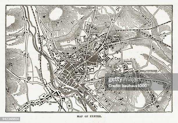
map of exeter in devon, england victorian engraving, 1840 - exeter map stock illustrationsMap of Exeter in Devon, England Victorian Engraving, 1840Map, Exeter - England
old map to illustate the campaigns of 1685 and 1688 in the west of england - exeter map stock pictures, royalty-free photos & imagesOld map to illustate the Campaigns of 1685 and 1688 in the West of EnglandMap
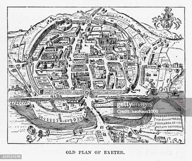
old plan of exeter in devon, england victorian engraving, 1840 - exeter map stock illustrationsOld Plan of Exeter in Devon, England Victorian Engraving, 1840Exeter - England
floor plan map of cathedral church of saint peter in exeter, england - 19th century - exeter map stock illustrationsFloor Plan Map of Cathedral Church of Saint Peter in Exeter, England - 19th CenturyOld-fashioned, Archival, Cathedral
ri washington vector map green - exeter map stock illustrationsRI Washington Vector Map GreenRhode Island, Map, North Kingstown
antique map of exeter, england - 19th century - exeter map stock illustrationsAntique Map of Exeter, England - 19th Century
old plan of exeter in devon, england victorian engraving, 1840 - exeter map stock illustrationsOld Plan of Exeter in Devon, England Victorian Engraving, 1840England, Exeter - England, Map
map of exeter in devon, england victorian engraving, 1840 - exeter map stock illustrationsMap of Exeter in Devon, England Victorian Engraving, 1840
old plan of exeter in devon, england victorian engraving, 1840 - exeter map stock illustrationsOld Plan of Exeter in Devon, England Victorian Engraving, 1840Medieval, Map
Bird's eye view map by John Hooker, engraved by Remegius Hogenberg: 8000 inhabitants lived in 93 acres. The town was economically powerful and well...Map of the English city of Exeter by John Hooker, 1587. Artist: John Hooker
nh rockingham vector map green - exeter map stock illustrationsNH Rockingham Vector Map GreenNottingham, New Hampshire, Map
nh rockingham exeter vector road map - exeter map stock illustrationsNH Rockingham Exeter Vector Road MapStreet Map, Exeter - New Hampshire
antique map of exeter, england - 16th century - exeter map stock illustrationsAntique Map of Exeter, England - 16th Century
Exter Cathedral', circa 20th Century. [John Bartholomew & Son, Edinburgh]Artist John Bartholomew.Exter Cathedral
Poster produced for British Railways to promote rail travel to the West of England from London. The poster shows a map of Devon and Cornwall with the...�Atlantic Coast Express�, BR poster, 1948-1965.
map of exeter in devon, england victorian engraving, 1840 - exeter map stock illustrationsMap of Exeter in Devon, England Victorian Engraving, 1840
wilkes-barre pa area 120k vector road map blue - exeter map stock illustrationsWilkes-Barre PA Area 120K Vector Road Map Blue
wilkes-barre pa area 120k vector road map beige - exeter map stock illustrationsWilkes-Barre PA Area 120K Vector Road Map Beige
Prime Minister Andy Burnham looks at a D-Day weather map shown by Sarah Jackson, Head of International Affairs during a visit to the met office on...Prime Minister Andy Burnham Continues National Tour With A Visit To Devon
Britain's Prime Minister Andy Burnham looks at a D-Day weather map shown by Sarah Jackson, Head of International Affairs during a visit to the Met...BRITAIN-POLITICS-DROUGHT-WILDFIRED Day
Prime Minister Andy Burnham looks at a D-Day weather map shown by Sarah Jackson, Head of International Affairs during a visit to the met office on...Prime Minister Andy Burnham Continues National Tour With A Visit To Devon
Prime Minister Andy Burnham looks at a D-Day weather map shown by Sarah Jackson, Head of International Affairs during a visit to the met office on...Prime Minister Andy Burnham Continues National Tour With A Visit To Devon
Prime Minister Andy Burnham looks at a D-Day weather map shown by Sarah Jackson, Head of International Affairs during a visit to the met office on...Prime Minister Andy Burnham Continues National Tour With A Visit To Devon
Inside GDK German Doner Kebab takeaway restaurant, Exeter, Devon, England, UK established Berlin 1989.Inside GDK German Doner Kebab takeaway restaurant, Exeter, Devon, England, UK established Berlin 1989
Devonshire, engraved by Jodocus Hondius from John Speed's Theatre of the Empire of Great Britain, pub. By John Sudbury and George Humble, 1611-12Private Collection
nh rockingham stratham vector road map - exeter map stock illustrationsNH Rockingham Stratham Vector Road Map
Photo Ryan McFadden George and Gloria Jean Meiser of Exeter in the Henry Hanssen Library behind the Historical Society. Behind them is a map of...11\7\12 photo Ryan McFadden George and Gloria Jean Meiser of Exeter in the Henry Hanssen Library behind the Historical Society. Behind them is a map of Reading from 1881 that hangs in the library office.
Photo Ryan McFadden 200300674 Exeter Headshots spring sports; brett neider softballThe names of the Short family on the map during the PA Says No More Rally held by the Pennsylvania Coalition Against Domestic Violence Monday at the Capitol Photo by Lauren A. Little Domestic Violence Rally 10/17/2016
Photo Ryan McFadden Exeter Commons ribbon cutting ceremony;10/11/06 photo Ryan McFadden 200602295 Energy Harvest Grant press conference held along the river at RACC; a map they had on display of the overall area
Adam N. Crosier, "Pacer," of Exeter Township keeps his Appalachian Trail in Pennsylvania map, which includes the elevation changes and mile markers...Adam N. Crosier, "Pacer," of Exeter Township keeps his Appalachian Trail in Pennsylvania map, which includes the elevation changes and mile markers with significant points, handy in his left pants pocket. Photo by Jeremy Drey 6/25/2008
Adam N. Crosier, "Pacer," of Exeter Township finds his place on the his Appalachian Trail in Pennsylvania map, which includes the elevation changes...Adam N. Crosier, "Pacer," of Exeter Township finds his place on the his Appalachian Trail in Pennsylvania map, which includes the elevation changes and mile markers with significant points. Photo by Jeremy Drey 6/25/2008
Benjamin Donn Wall Map of Devonshire and Exeter, England.1765 Benjamin Donn Wall Map of Devonshire and ExeterExploration
Glassware - England - 20th century. Paperweight South Devon Exeter.Close-up of a paperweight, Exeter, England
Benjamin Donn Wall Map of Devonshire and Exeter, EnglandBenjamin Donn Wall Map of Devonshire and Exeter